Introduction
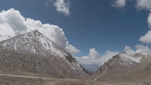
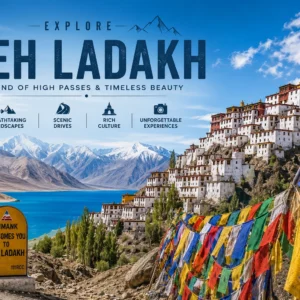
Perched high in the cold desert of Ladakh, Khardung La is one of the most legendary mountain passes in the world. Sitting on the ancient trade route that once connected India with Central Asia via the Silk Road, it is widely known as one of the highest motorable roads globally.
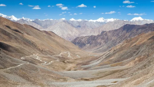
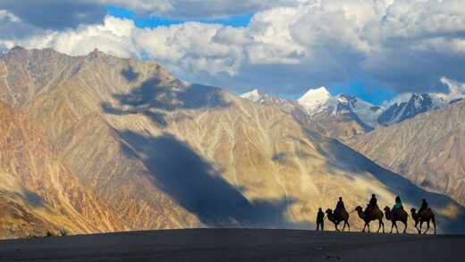
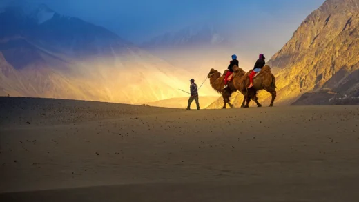
Located north of Leh, this dramatic pass serves as the gateway to the stunning Nubra Valley, a region famous for sand dunes, double-humped camels, and remote Himalayan villages.
For bikers, road-trippers, photographers, and adventure seekers, Khardung La is not just a destination—it is a milestone. The journey is filled with winding roads, snow walls, prayer flags fluttering in freezing winds, and breathtaking views of the Karakoram range.

Historically, Khardung La played a crucial role in Ladakh’s trade and military logistics. Today, it remains a symbol of high-altitude endurance and adventure tourism.
The best time to visit is May to September, when the road is open and weather conditions are relatively stable.
Quick Facts
| Category | Details |
|---|---|
| Elevation | ~5,359 m (17,582 ft) |
| District | Leh District |
| Region | Ladakh, India |
| Coordinates | 34.279°N, 77.604°E |
| Road/Location | Leh–Nubra Highway |
| Managed By | Border Roads Organisation (BRO) |
| Best Season | May to September |
| Road Status | Seasonal (snow-blocked in winter) |
| Temperature | -25°C to 15°C |
| AMS Risk | Very High |
| Mobile Network | Limited (BSNL/occasionally Jio near Leh) |
| Fuel Availability | Only in Leh |
| Nearest ATM | Leh |
| Nearest Hospital | SNM Hospital, Leh |
| Entry Permit | Inner Line Permit required (for foreigners) |
| Difficulty Level | High (due to altitude) |
| Ideal Vehicle | SUV, 4×4, Royal Enfield bikes |
Location
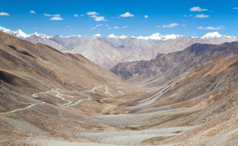
Khardung La lies about 39 km north of Leh and acts as the primary route connecting the Indus Valley with the Nubra Valley. The pass is part of the greater Karakoram mountain system, surrounded by rugged peaks, glaciers, and barren alpine landscapes.
Nearby Villages
- South Pullu
- North Pullu
- Khardung village
- Diskit (in Nubra Valley)
Nearby Attractions
- Diskit Monastery
- Hunder Sand Dunes
- Turtuk village
- Shyok River Valley
Geographic Significance
Khardung La sits at a strategic position near the Siachen Glacier region, making it historically important for military logistics. It also forms part of one of the world’s highest motorable road networks.
Distance Table
| Destination | Distance | Travel Time |
|---|---|---|
| Leh | ~39 km | 1.5–2 hrs |
| Kargil | ~216 km | 6–7 hrs |
| Nubra Valley (Diskit) | ~120 km | 4–5 hrs |
| Pangong Lake | ~200 km | 6–7 hrs |
| Hanle | ~330 km | 10–12 hrs |
| Manali | ~473 km | 2 days (road journey) |
| Srinagar | ~434 km | 2 days (road journey) |
History
The name Khardung La is derived from Ladakhi words meaning “Pass of the Lower Castle.” Historically, it was part of the ancient Silk Route network that connected Leh with Yarkand in Central Asia.
Caravans carrying silk, spices, and precious stones once crossed this pass under extreme conditions. The route was vital for trade between India, Tibet, and Central Asia.
In modern times, Khardung La gained strategic importance due to its proximity to the Siachen Glacier. It has been maintained by the Indian Army and BRO for military logistics and supply movement.
Today, it stands as both a historical route and a symbol of India’s high-altitude engineering achievement.
Geography
Khardung La showcases dramatic Himalayan geography:
- Mountains: Part of the Karakoram and Ladakh ranges
- Valleys: Indus Valley (south), Nubra Valley (north)
- Rivers: Shyok River and Nubra River system downstream
- Lakes: Seasonal glacial melt streams
- Terrain: Rocky, snow-covered slopes with loose gravel roads
- Flora: Sparse alpine vegetation due to extreme altitude
The landscape is mostly barren but visually striking, with sharp ridges and vast open skies.
Climate
Month-wise Climate Table
| Month | Temperature | Weather | Tourist Flow | Recommendation |
|---|---|---|---|---|
| Jan | -20°C to -30°C | Heavy snow | Closed | Not accessible |
| Feb | -20°C to -25°C | Extreme cold | Closed | Avoid travel |
| Mar | -15°C to -20°C | Snowbound | Closed | Not recommended |
| Apr | -5°C to -10°C | Snow melting | Low | Road may open late |
| May | 0°C to 10°C | Cold, windy | Moderate | Good start of season |
| Jun | 5°C to 15°C | Pleasant | High | Best time |
| Jul | 7°C to 15°C | Mild | Peak | Ideal |
| Aug | 6°C to 14°C | Occasional rain | High | Good |
| Sep | 2°C to 10°C | Cold begins | Moderate | Excellent |
| Oct | -5°C to 5°C | Snowfall begins | Low | Risky |
| Nov–Dec | -10°C to -25°C | Heavy snow | Closed | Not accessible |
How to Reach
From Leh
- Distance: ~39 km
- Travel Time: 1.5–2 hours
- Route: Leh → South Pullu → Khardung La
- Fuel Stops: None (fuel only in Leh)
- Food Stops: South Pullu Army Café
- Road Quality: Narrow, steep, partly paved
- Transport: Taxi, bike rental, private SUV
Nearest Airport
From Srinagar or Manali
Travelers usually reach Leh via road before heading to Khardung La.
Top Experiences
- High-altitude photography with snow walls
- Motorcycle expedition on Royal Enfield
- Viewing Karakoram mountain ranges
- Experiencing extreme altitude climate
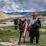
- Cultural interaction with Ladakhi locals
- Stargazing in clear Himalayan skies
- Snow play during summer months
- Adventure road-tripping from Leh to Nubra
Nearby Attractions
| Attraction | Distance | Highlights |
|---|---|---|
| Nubra Valley | 120 km | Sand dunes, camels |
| Diskit Monastery | 118 km | Giant Buddha statue |
| Hunder | 130 km | Bactrian camels |
| Turtuk | 170 km | Balti culture |
| Shyok River | En route | Scenic river valley |
Accommodation & Food
There are no stays at Khardung La itself due to extreme weather. Accommodation is available in:
Leh
- Hotels: Budget to luxury hotels in Leh town
- Homestays: Ladakhi family stays
- Camps: Seasonal camping near Nubra route
Food Options
- Tea stalls at South Pullu (Maggi, tea, soup)
- Restaurants in Leh (Ladakhi, Indian, Tibetan cuisine)
- Popular dishes: Thukpa, momos, butter tea, skyu
Essential Travel Information
- Fuel available only in Leh
- Limited mobile network (BSNL best option)
- No ATMs beyond Leh
- Inner Line Permit required for foreign tourists
- Drone usage restricted (military zone)
- Photography allowed but respect army checkpoints
Safety Guide
Altitude Sickness (AMS)
Khardung La is extremely high altitude. Symptoms include headache, nausea, and dizziness. Acclimatize in Leh for 24–48 hours before visiting.
Road Safety
- Roads are steep and narrow
- Avoid speeding and overtaking
- Weather changes quickly
Emergency Tips
- Carry oxygen cylinder
- Keep emergency medicines
- Inform hotel before departure
Travelers Advice
- Solo travelers should avoid night travel
- Families should plan short visits only
- Women travelers: safe but follow standard precautions
Packing Checklist
- ID proofs and permits
- Warm layered clothing
- Gloves, thermal wear, wool caps
- Sunglasses (UV protection)
- Sunscreen (high SPF)
- Personal medicines
- Power bank
- Water bottles and snacks
Suggested Itinerary
One-Day Itinerary
- Early morning Leh departure
- Stop at South Pullu
- Reach Khardung La summit
- Return to Leh by afternoon
Two-Day Itinerary
Day 1: Leh acclimatization + local sightseeing
Day 2: Khardung La + return or continue to Nubra Valley
Budget Guide (Per Person)
| Category | Backpacker | Mid-range | Luxury |
|---|---|---|---|
| Accommodation | ₹800–1500 | ₹2000–5000 | ₹8000+ |
| Transport | ₹500–1500 | ₹2000–4000 | ₹6000+ |
| Food | ₹300–700 | ₹1000–2000 | ₹3000+ |
| Total/day | ₹1500–3500 | ₹5000–11000 | ₹15000+ |
Responsible Tourism
- Avoid littering mountain zones
- Carry reusable bottles
- Respect army checkpoints
- Do not disturb wildlife
- Support local Ladakhi businesses
- Minimize plastic usage
Travel Tips
- Acclimatize in Leh before visiting
- Start early morning trips
- Avoid heavy meals before ascent
- Carry cash (no ATMs nearby)
- Check weather before departure
- Keep fuel tank full in Leh
- Wear layered clothing
- Drive slowly on curves
- Stay hydrated
- Avoid alcohol before travel
Frequently Asked Questions
1. Is Khardung La the highest motorable road in the world?
It is among the highest motorable roads, though exact rankings vary globally.
2. Is it safe to travel to Khardung La?
Yes, with proper acclimatization and precautions.
3. Do I need a permit?
Foreign tourists need an Inner Line Permit.
4. Can beginners ride bikes here?
Not recommended for inexperienced riders.
5. Is there snowfall in summer?
Yes, patches of snow remain even in summer.
6. How far is it from Leh?
Approximately 39 km.
7. Are food facilities available?
Only small tea stalls at South Pullu.
8. What is AMS?
Altitude Mountain Sickness due to low oxygen levels.
9. Can families visit?
Yes, but only for short durations.
10. What is the best time to visit?
May to September.
Conclusion
Khardung La is more than a mountain pass—it is an experience that defines Ladakh’s raw beauty and extreme adventure spirit. From its historic Silk Route legacy to its modern-day role as a gateway to Nubra Valley, it remains a must-visit for anyone exploring Ladakh’s high-altitude wonders.